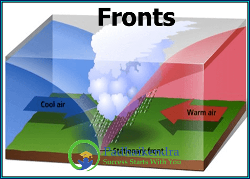
Fronts are the boundaries between two air masses with different characteristics, such as temperature, humidity, and density. These boundaries can produce a variety of weather phenomena, ranging from gentle rain showers to severe thunderstorms.
There are three main types of fronts:
- Cold front: A cold front occurs when a colder air mass replaces a warmer air mass. As the cold air mass moves into the warm air mass, it pushes the warm air up rapidly, creating a steep slope. This rapid lifting of warm air can lead to the formation of towering cumulus clouds and thunderstorms, which can produce heavy rain, lightning, and strong winds.
- Warm front: A warm front occurs when a warm air mass moves into an area occupied by colder air. As the warm air mass moves over the colder air, it rises gradually, creating a gentle slope. This can lead to the formation of stratus clouds and light rain or drizzle.
- Stationary front: A stationary front occurs when two air masses with different characteristics meet, but neither is strong enough to push the other away. The front remains stationary, with both air masses remaining in place for an extended period. This can lead to the formation of prolonged periods of precipitation, often in the form of light to moderate rain.
Fronts can also interact with other weather systems, such as low-pressure systems and high-pressure systems, to produce a wide range of weather conditions. For example, a cold front approaching a low-pressure system can intensify the storm by increasing the amount of lifting and instability in the atmosphere.
Understanding the dynamics of fronts is crucial for predicting weather patterns and managing the impacts of severe weather events. Weather forecasters use a range of tools and techniques, including weather balloons, radar, and satellite imagery, to track the movement and characteristics of fronts and their associated weather phenomena.


